

Morteratsch Glacier - Where the Ice Writes Its Own History and the Climb to Bovalhütte, Bernina Range in Switzerland
- 4B Travel Guide
- 6 days ago
- 13 min read

The Morteratsch Glacier tongue seen from the moraine trail, Piz Bernina rising behind
Morteratsch, Switzerland
Note: Tucked into the Bernina massif of the Engadin, Val Morteratsch is home to the longest glacier in the Alps' eastern range — a river of ice flowing down from Piz Bernina and Piz Palü, retreating a little further every single year, and one of the most closely studied glaciers on Earth.
There's a particular quality of silence in the Val Morteratsch — the kind that settles over you the moment the train doors close behind you and the platform empties out. Ahead, a valley of stone and ice, carved by a glacier that has been retreating in slow, visible increments for over a century. Walking here isn't just a hike. It's watching geological time move at a pace you can almost keep up with.
Note: The name itself carries some history — "Morteratsch" likely derives from Romansh, possibly linked to "mort" (death) combined with a term for stony ground, though its exact etymology is debated; some trace it to pre-Romance Alpine roots referring to a "dead" or barren rocky area, fitting for a landscape scoured by ice.
Why Morteratsch Is the Hike Most People Rush Past
Most travellers on the Bernina Express see Morteratsch for exactly ninety seconds — a flash of white through the train window somewhere between St. Moritz and the pass. That is a mistake, and it is one you don't have to repeat.
The moraine trail through larch forest, engraved year-markers along the path
Morteratsch sits at the foot of a valley that does something few alpine landscapes manage: it lets you watch time move. The trail up from the station is gentle, wide, and shaded by larch and stone pine, and along the way small engraved stones interrupt the path — 1900, 1920, 1950, 2000 — each one marking exactly where the glacier's edge stood in that year, drawn from historical surveys and photographs. You walk past a century of retreat before the ice itself even comes into view. When it finally does, grey-white and fissured against dark rock, the distance you've just covered lands somewhere between wonder and grief.
The Bovalhütte terrace, Piz Bernina and Piz Palü directly opposite
From the glacier tongue, the trail climbs on toward the Bovalhütte (Chamanna da Boval, SAC — boval.ch), a hut perched at roughly 2,500 meters with what might be the single best panoramic seat in the valley. Stay the night if your schedule allows — the light shifts across the ice through the evening, gold to pink to a strange blue-grey, and an early walk out onto the moraine at first light, before the day-trippers arrive, is worth the extra effort on its own.
Tour Short Description
Morteratsch is the trailhead to the longest glacier in the Bernina range, and one of the most accessible high-alpine glacier hikes in Switzerland. A gentle valley walk leads past a century of retreat markers to the glacier tongue, then climbs to the Bovalhütte — an SAC hut with an unmatched panorama of Piz Bernina and Piz Palü. Base yourself at the foot of the valley in the hotel or campsite, both with direct glacier views, or commute in from nearby Pontresina.
Language: German and Romansh (Puter dialect) are spoken locally; Italian and English are widely understood in hospitality, given the region's proximity to the Bernina line and its international hiking crowd.
The Glacier
Morteratsch is the longest glacier in the Bernina range, a river of ice flowing down from Piz Bernina and Piz Palü, and it announces its scale slowly. The approach trail runs gentle and wide through larch and stone-pine forest, and along the way, small engraved markers interrupt the path — each one a year, each one a point where the ice once reached. 1900. 1920. 1950. You walk past a century of retreat before the glacier itself even comes into view, and when it finally does, gray-white and fissured against the dark rock, the distance you've just walked settles into something closer to grief than wonder. Both, really.
The Glacier's Story
Morteratsch has been one of the most closely studied glaciers in the Alps, precisely because its retreat has been so dramatic and so well documented. Systematic measurements began in the late 19th century, making it one of the longest continuous glacier monitoring records in the world.
Around 1850, near the end of the Little Ice Age, Morteratsch reached close to its maximum historical extent — the ice tongue extended much further down the valley than it does today, close to where the train station now stands. Since then, it's retreated more than 2 kilometers, and the pace has accelerated sharply since the 1980s and 90s. In some recent years it has lost over 30 meters of length annually — among the fastest retreat rates recorded for any glacier in the Alps.
Those engraved year-markers you pass on the trail (1900, 1920, 1950, and so on) aren't decorative — they were placed using historical survey and photographic records to mark exactly where the glacier's snout stood in each era. Walking the trail is, quite literally, walking through a timeline of loss.
The Valley and Region
The Val Morteratsch sits within the Bernina massif, part of the Engadin region of Graubünden, an area shaped by centuries of alpine farming, mule trails, and later, glacier tourism. The opening of the Rhaetian Railway's Bernina line in the early 20th century (completed 1910, later recognized as a UNESCO World Heritage line) transformed access to the valley — what had been a remote high-alpine approach became reachable by train directly from St. Moritz and Pontresina, and Morteratsch grew as a modest waypoint for glacier excursions.
The Bovalhütte itself has roots as a 19th-century alpine refuge, expanded and modernized over the decades by the Swiss Alpine Club (SAC) as glacier trekking and mountaineering in the Bernina group grew in popularity — Piz Bernina, the highest peak in the Eastern Alps, and Piz Palü drew increasing numbers of climbers and, later, hikers who simply wanted the view.
Today, Morteratsch has become something of an open-air case study in climate change — scientists, students, and casual hikers alike walk the same path, but increasingly what draws people isn't just the ice, but watching, in real time, how quickly it's disappearing.
Location: Morteratsch lies in the Val Bernina, canton of Graubünden, in the Engadin region of southeastern Switzerland — about 10 minutes by train from Pontresina and 25 minutes from St. Moritz.
Googlemaps Link: https://maps.app.goo.gl/4e45CQDXXzEdVoJj9
How to Reach Morteratsch?
From Zürich — Direct and connecting trains run via Chur and the Albula or Vereina route to St. Moritz, then onward on the Bernina line to Morteratsch, taking roughly 3.5–4 hours in total — one of the most scenic rail journeys in the country. By car, it's approximately 200 km via the A3 and A13, roughly 3 hours through the San Bernardino or Julier Pass.
From St. Moritz — Morteratsch is a short, dramatic ride on the Rhaetian Railway's Bernina line, one leg of a UNESCO World Heritage rail route, taking about 20 minutes.
From Milan — Around 3 hours by car via the SS36 and the Bernina Pass road, or a connecting train via Tirano, the southern terminus of the Bernina Express — a popular day-trip route for northern Italians.
By car or motorbike — Morteratsch sits directly off the main Engadin/Bernina road, with parking at the station. The Bernina Pass road above the valley is among the best riding in Graubünden, with glacier views built into the route.
Swiss Train Tickets and Schedules: https://www.sbb.ch/en
Some useful distances:
10 km / 20 minutes from Pontresina
25 km / 40 minutes from St. Moritz
200 km / 3 hours from Zürich
180 km / 3 hours from Milan via the Bernina Pass
Weather: Morteratsch sits at around 1,900 meters, with short, bright alpine summers and long winters. Even in July and August, mornings can be cold near the glacier — layers are essential, and the hut nights can drop close to freezing regardless of season.
Gletscherpfad Morteratsch — The Easy Way In
The gravel path along the valley floor, glacier visible ahead through the larches
Not every visit to Morteratsch needs to end at a hut door 700 meters up. The Gletscherpfad Morteratsch — the glacier path — is the valley's gentler option, and honestly the one most people should start with, whether or not they go further.
[Location: https://maps.app.goo.gl/cAv1W1XS1WUXX8bu6]
What It Is
The Gletscherpfad runs from the Morteratsch train station up the valley floor to the glacier tongue and viewpoint — a wide, well-maintained gravel path with almost no elevation gain, following the route of the old glacier forefield as the ice has retreated. It's the same path that carries the historical year-markers (1900, 1920, 1950...) tracking exactly how far Morteratsch has pulled back over the past century, so even this easy stretch comes with its own quiet narrative built in.
On foot, it's about 3.5–4 km each way, roughly an hour at an easy pace, flat enough for families, older visitors, or anyone who just wants the glacier view without the climb.
By bike, the path is equally rideable — wide gravel, gentle gradient, and a pleasant 20–30 minute ride up with the glacier growing steadily larger ahead of you. E-bikes and regular mountain bikes are both common here; it's an easy add-on if you're already touring the valley on two wheels.
Either way, you end at the same reward: a close, open view of the glacier tongue and the moraine field in front of it, with Piz Bernina and Piz Palü stacked up behind. From here, the choice is yours — turn back for a short, satisfying outing, or continue on and start the steeper climb toward the Bovalhütte if you've got the legs and the time.
Why Start Here
It's the ideal warm-up or the ideal endpoint, depending on your day. Arriving by train with only a few hours before the next connection? The Gletscherpfad alone is worth the stop. Staying overnight at the hotel or campsite and want an easy evening walk after setting up? This is it. And if the Bovalhütte climb is the goal, walking or riding the Gletscherpfad first is the natural, unhurried way to arrive at the base of the real ascent.
The Great Hike to Bovalhütte
From the glacier tongue, the trail turns and climbs — not brutally, but honestly, gaining height in switchbacks up the valley's flank. This is where the walk changes character: forest gives way to open alp, the roar of the glacier's meltwater recedes below, and the whole Bernina massif starts to unfold behind you, ridge after ridge, ice after ice.
The Bovalhütte (Chamanna da Boval, run by the SAC — boval.ch) sits at around 2,500 meters with what might be the single best panoramic seat in the valley: the glacier laid out below in its entirety, Piz Bernina and Piz Palü rising directly opposite, close enough to feel their weather changing hour by hour.
Staying overnight here is the move, if you can. Arrive in the afternoon, claim a spot on the terrace, and watch the light shift across the ice as the sun drops — the glacier turns gold, then pink, then a strange blue-grey before the stars take over completely. From the hut, you have options the day-hiker doesn't: an early walk further onto the moraine and glacier margins at first light, when the ice is calm and the air is knife-clear, before descending back down to Morteratsch at your own pace. Book ahead in summer — it's a popular hut, and rightly so.
Where to Base Yourself
Morteratsch itself is barely a hamlet — a train station, a hotel, a campsite, and the trailhead — but that's exactly its appeal. Hotel Morteratsch offers straightforward alpine comfort right at the foot of the valley, ideal if you want a proper bed and an early start.
For something more memorable, though, the Morteratsch campsite is hard to beat. Pitch your tent with a direct, uninterrupted view of the glacier and the surrounding peaks — falling asleep and waking up to that view is its own kind of overnight hike. The facilities are solid: clean washrooms, a restaurant on site, and none of the compromises you'd expect from a campground in such a dramatic setting.
If you'd rather have more restaurants, shops, and a livelier evening scene, Pontresina makes an excellent base a few kilometers down the valley. It's a genuinely lovely village in its own right, and the bus connection to Morteratsch is quick and frequent — commute in for the trailhead, commute back for dinner and a proper night's sleep.
Getting There
Morteratsch is easy to reach by train — it sits directly on the Rhaetian Railway's Bernina line, one of the most scenic rail routes in the Alps in its own right, so the journey there is already part of the experience. By car, it's a short, well-signed drive off the main Engadin/Bernina road with parking at the station. And for those arriving by motorbike, the pass roads leading into the valley (the Bernina Pass road especially) are among the best riding in Graubünden — sweeping curves with glacier views thrown in as a bonus.
However you arrive, give the glacier at least a full day, and the hut at least one night if your legs and your schedule allow it. Some places reward speed. Morteratsch rewards the opposite.
Local Cuisine
The Berggasthaus & SAC Hut: The Engadin's Signature Dining Tradition
A Berggasthaus — or, higher up, an SAC hut like the Bovalhütte — is the alpine equivalent of a village tavern, except built for altitude rather than shade. The tradition here isn't about caves and cool cellars; it's about shelter, self-sufficiency, and food built to fuel a body that's just climbed a few hundred meters of moraine.
Where it comes from
Long before hiking was recreation, these huts existed for shepherds, mule drivers, and later mountaineers moving through the Bernina passes — simple stone-and-timber refuges offering warmth, a bed, and something hot to eat after a day exposed to alpine weather. Supplies had to be carried or hauled in by cable, so menus were built around what could be stored, preserved, or produced locally: dried meats, hard cheeses, rye bread, barley. Over time, the Swiss Alpine Club (SAC) formalized many of these refuges, and what had been a practical waystation became a destination in its own right — people now hike up simply for the meal and the view, not just the shelter.
What a hut looks like today
Built from stone and timber, low-roofed against wind and snow, often perched directly on a ridge or moraine with the glacier in full view from the terrace
Communal wooden tables, both indoors by the fire and outside when the weather allows
Reached only on foot — no roads, no shortcuts, which is part of the appeal
No pretension: simple crockery, house-poured wine, hearty portions
Many, like the Bovalhütte, are still run by dedicated hut wardens (Hüttenwart) who live on-site for the season, sometimes for years running
What you eat and drink there
Hut menus are deliberately simple and built around what actually sustains a day of alpine walking:
Gerstensuppe – the classic Bündner barley soup, thick with vegetables and often ham, standard fuel at nearly every hut in Graubünden
Rösti – with a fried egg, alpine cheese, or Bündnerfleisch (air-dried alpine beef) on top
Pizzoccheri or Capuns – Engadin and Bündner specialties, buckwheat pasta or chard-wrapped dumplings, showing the valley's proximity to both German and Italian-speaking Switzerland
Bündnerfleisch and alpine cheeses – air-dried, cured, and aged locally, often produced by the same families running the alp below
Veltliner or a simple Bündner red – served in small carafes, poured without ceremony
Why They Matter to the Travel Experience
Alpine huts are one of the few genuinely un-touristed traditions left in a valley that otherwise sees its share of day-trippers and Bernina Express passengers. They're not designed for the crowd passing through on the train — they're where hikers, climbers, and locals have always gone after a day on the ice, which is precisely what makes stopping at one feel earned rather than staged. Reaching the Bovalhütte requires actual effort — the climb up from the glacier tongue, several hundred meters of switchbacks with the pack on your back — and that effort is the point: a hut meal is unhurried, communal, and deliberately disconnected from anything you could drive to.
The Engadin's alpine food sits at the crossroads of Bündner tradition and the practical needs of altitude: barley soup thick enough to be a meal on its own, rösti piled with alpine cheese, air-dried beef sliced thin enough to see light through it. Nearly every hut menu carries some version of these, and the Bovalhütte is no exception — simple, generous plates built to refuel a body that's just walked past a century of retreating ice. Down in the valley, Hotel Morteratsch offers a more polished version of the same regional cooking, but the short climb up to the hut turns up the same unpretentious character found in refuges across Graubünden: house wine in small carafes, long wooden tables, and no ceremony about any of it.
Our new concept: Flower Therapy — Observe. Learn. Relax.
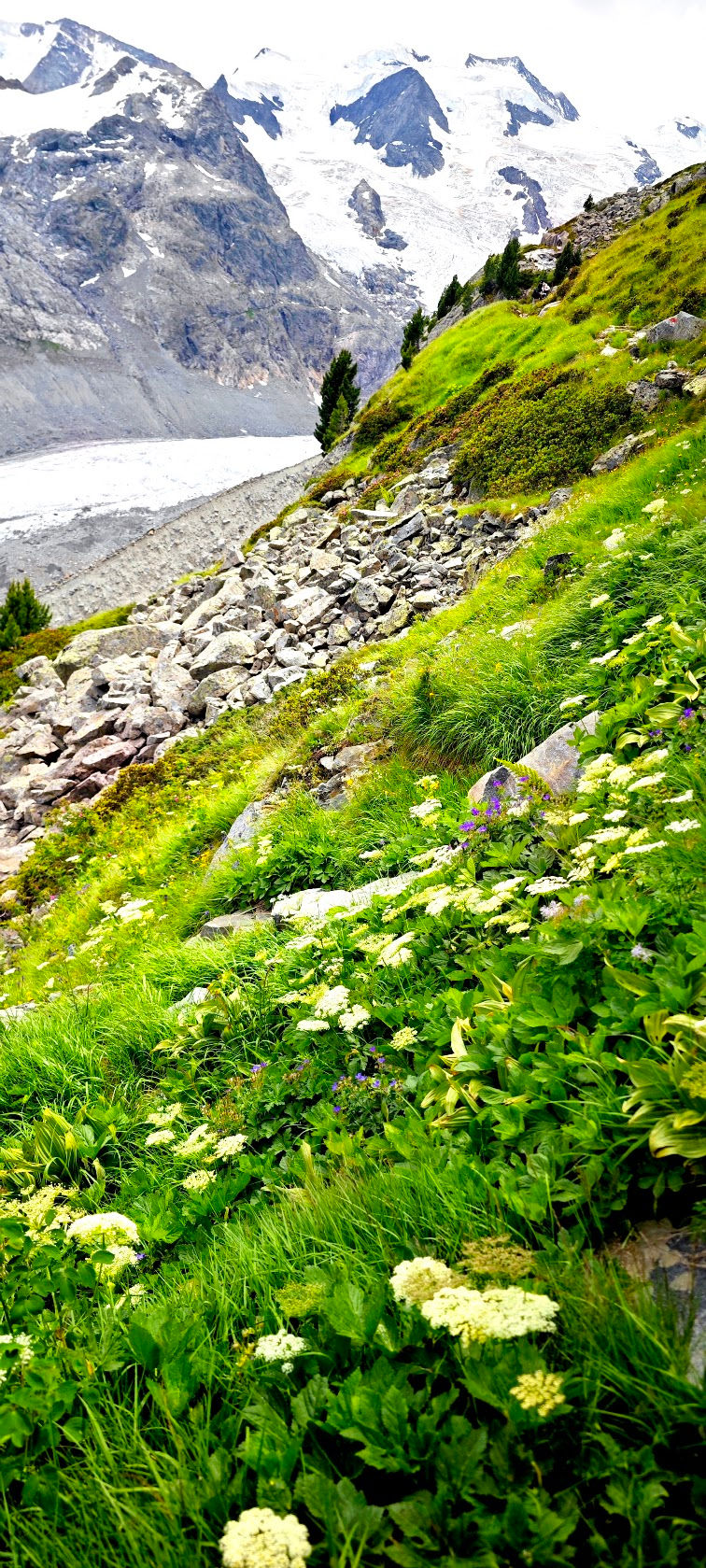
Alpine gentian in bloom along the moraine trail, glacier visible behind
Link to our Flower Therapy - : https://photos.app.goo.gl/Vi7cyhabNv7Lo4M28
There's a slower way to walk through Morteratsch, and it has nothing to do with distance or elevation. Somewhere between the roar of the glacier's meltwater and the silence of the high moraine, the valley floor and the alp meadows above it fill with something easy to miss if you're only looking up at the ice: an extraordinary density of alpine flowers, blooming in short, intense bursts through the brief high-altitude summer.
This is the idea behind Flower Therapy — a simple practice of pausing on a hike not to check a summit or hit a time, but to actually look. To crouch down at trail's edge, notice a flower you've walked past a hundred times without seeing, and learn its name. It costs nothing, it slows the body down in exactly the way alpine air asks you to, and it turns a hike into something closer to a moving meditation. Three steps: Observe. Learn. Relax.
Why Alpine Flowers, Why Here
Alpine plants live under enormous pressure — a growing season sometimes as short as eight weeks, brutal UV exposure, thin soil, and temperature swings that would kill most lowland species outright. What they've evolved in response is often startlingly beautiful: dense cushion growth, intense pigment, oversized blooms relative to the plant's size, all packed into a tiny window before the snow returns. Walking the Gletscherpfad or the climb toward Bovalhütte in July puts you right in that window, with the glacier as a backdrop most botanical gardens can't offer.
Some Flowers to Look For
Trumpet gentian (Gentiana clusii / acaulis) — an almost impossible blue, low to the ground, often growing right at the edge of the gravel path. Easy to miss, impossible to forget once you've seen it.
Alpenrose (Rhododendron ferrugineum) — the pink-red shrub that carpets whole hillsides in the Engadin in early-to-mid summer, especially on the slopes above the valley floor.
Edelweiss (Leontopodium alpinum) — the iconic one, though it prefers drier, rockier ground higher up; look carefully near exposed scree on the climb to Bovalhütte rather than the damp valley floor.
Alpine aster (Aster alpinus) — purple-blue, daisy-shaped, common in the meadows just below the hut.
Moss campion (Silene acaulis) — a tight, bright-pink cushion plant that grows directly on rock and gravel, one of the toughest and most quietly impressive flowers you'll pass.
Alpine forget-me-not (Myosotis alpestris) — small, intensely blue, often growing in small clusters near meltwater seeps along the trail.
Yellow alpine poppy (Papaver alpinum) — delicate, papery, found in rockier stretches, seemingly too fragile for the conditions it grows in.
How to Practice It
No equipment needed beyond a slower pace and, if you like, a small flower guide or an ID app for the moments curiosity gets the better of you. Stop where something catches your eye. Look closely — really closely — at the structure, the color, the way it's anchored against the wind. Learn its name if you can, or simply notice it without needing to. Then keep walking.
By the time you reach the glacier tongue, or the terrace at Bovalhütte, you'll have arrived twice over — once in your legs, and once in your attention.
Closing
Morteratsch is a valley that gives more the slower you move through it. A few hours are enough to walk the Gletscherpfad and stand in front of the ice. A full day, or an overnight at the Bovalhütte, lets you add the climb, the shifting light on the glacier at dusk, and an early walk out onto the moraine before anyone else is awake. It is one of the clearest places in the Alps to watch a landscape change in real time — and to understand, standing there, exactly what's being lost.
Hiking · Glacier · Mountains · Alpine Huts · SAC · Graubünden · Switzerland


Comments